Products


11481
$ 18.95 $ 27.00
Official NOAA Chart covering the Approaches to Port Canaveral Standard size: 52" wide by 36" tall If you would prefer a smaller, lighter and less bulky format, you may want...


11484
$ 18.95 $ 27.00
Ponce de Leon Inlet to Cape Canaveral Standard size: 36" wide by 47" tall If you would prefer a smaller, lighter and less bulky format, you may want to choose...


11486
$ 18.95 $ 27.00
Official NOAA Chart from St. Augustine Light to Ponce de Leon Inlet Standard size: 35" wide by 50" tall If you would prefer a smaller, lighter and less bulky format,...


11487N
$ 8.95 $ 27.00
Official NOAA Chart of the St. Johns River, Racy Point to Edgewater. This chart is printed from the most recent NOAA ENC data. Standard size: 22" wide by 34" tall Frugal...


11487S
$ 8.95 $ 27.00
Official NOAA Chart of the St. Johns River, Edgewater to Crescent Lake. This chart is printed from the most recent NOAA ENC data. Standard size: 22" wide by 34" tall Frugal...


11488
$ 18.95 $ 27.00
Amelia Island to St. Augustine 35" wide by 49" tall If you would prefer a smaller, lighter and less bulky format, you may want to choose the SMALL CRAFT Chart...


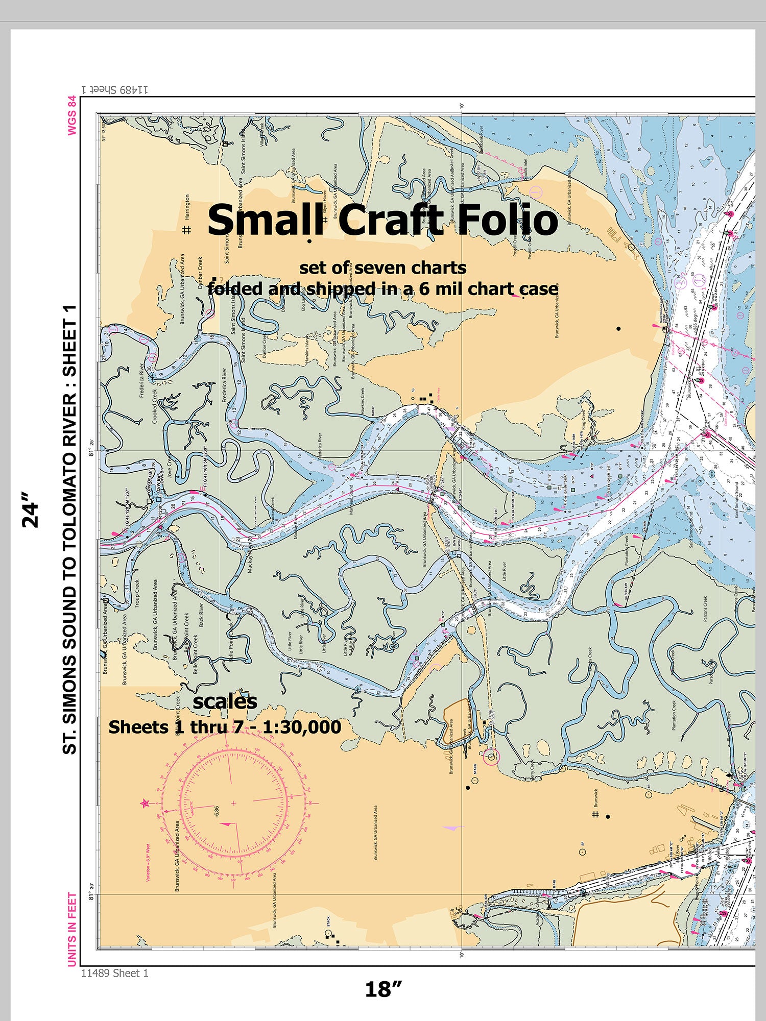
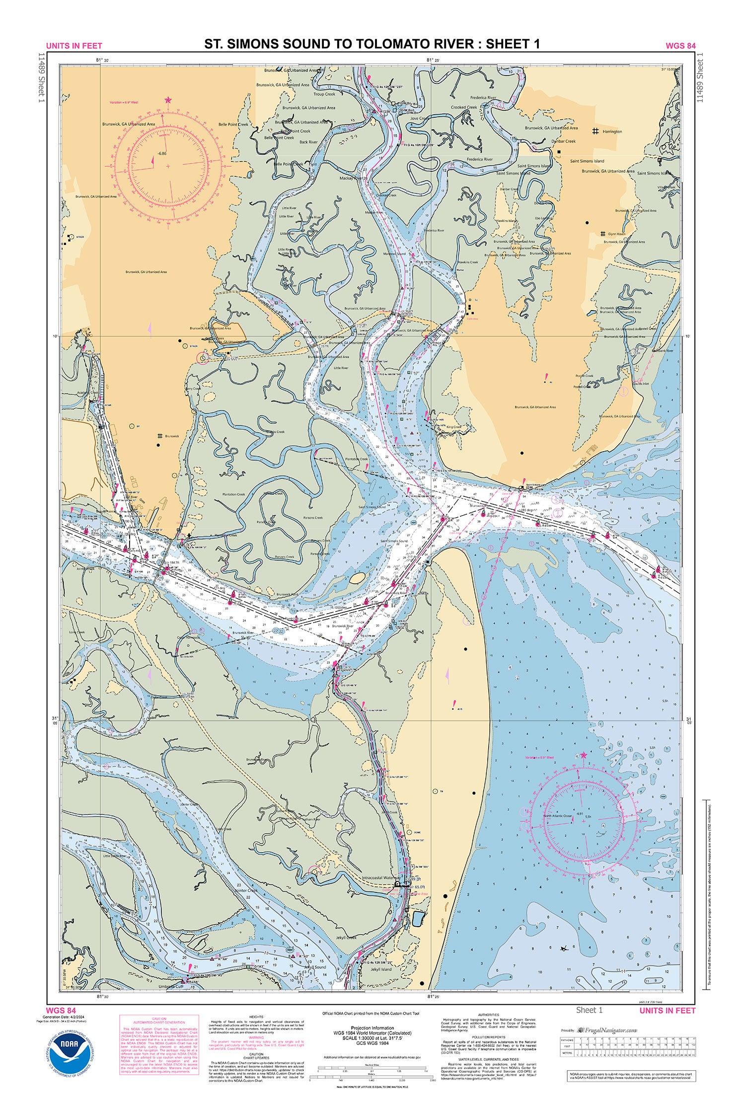
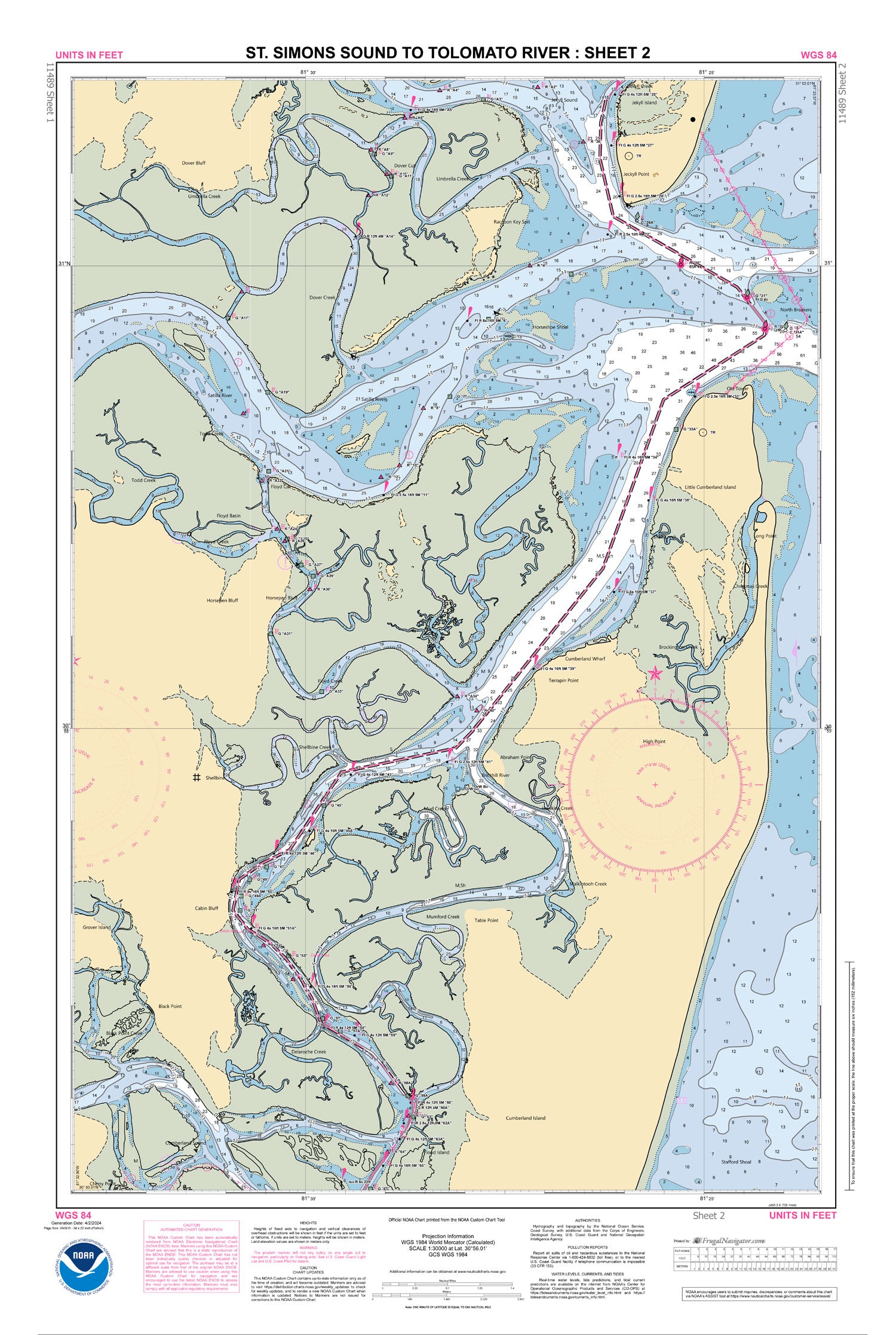
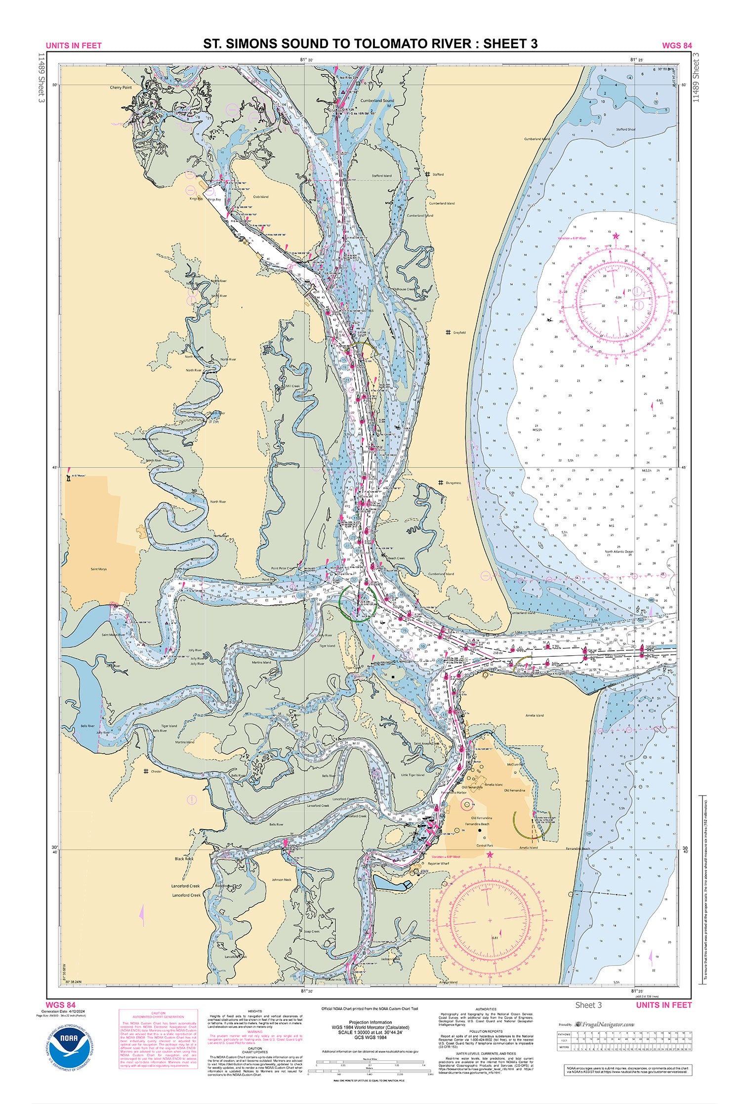
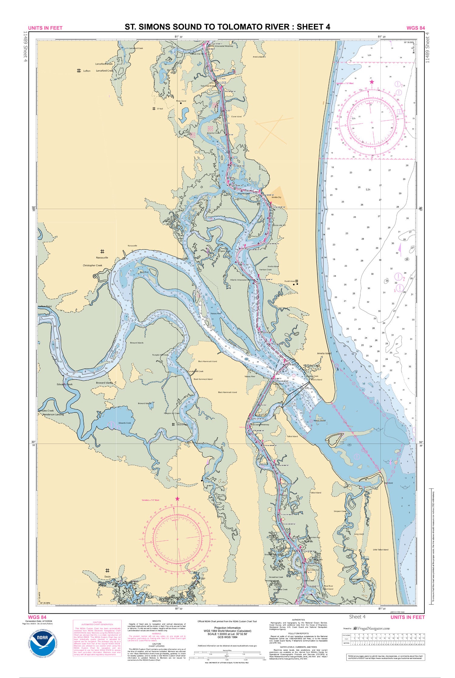
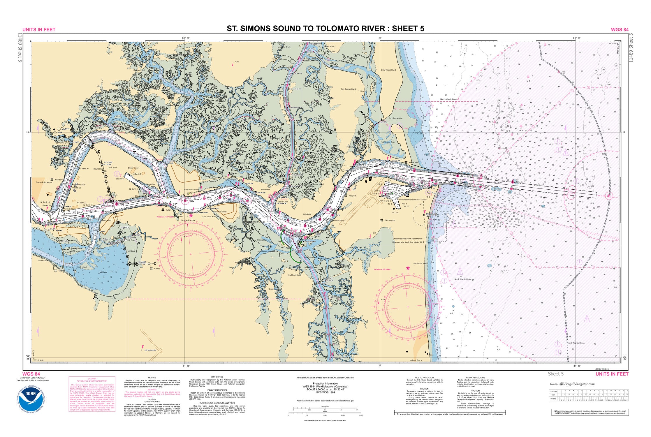
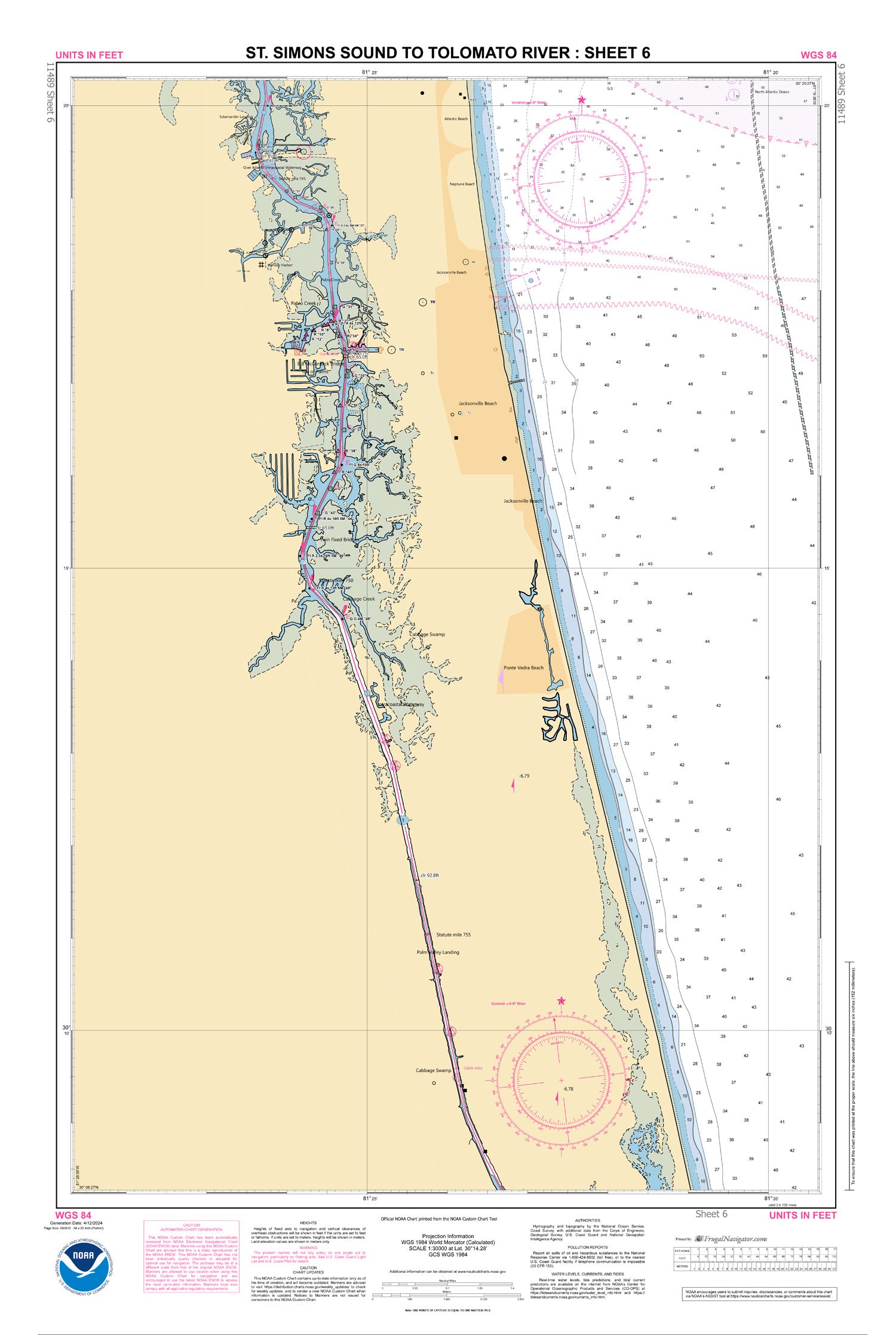
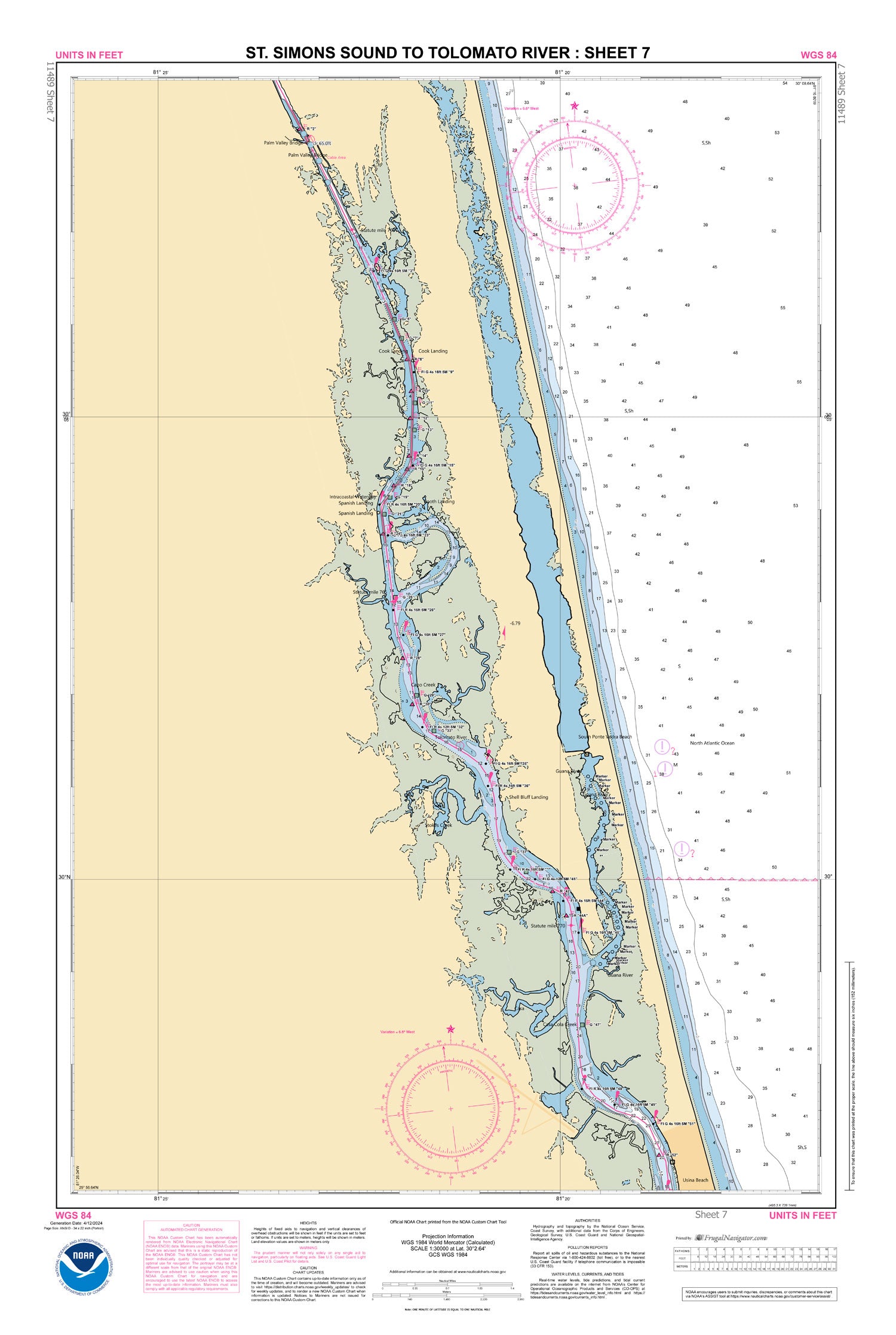
11489
$ 52.95
Official NOAA Chart for the Intracoastal Waterway : St. Simons Sound to Tolomato River. This Small Craft Folio Chart is printed from the most recent ENC data and consists of...


11490
$ 18.95 $ 27.00
Approaches to St. Johns River;St. Johns River Entrance 36" wide by 46" tall If you would prefer a smaller, lighter and less bulky format, you may want to choose the...


11491
Sold Out $ 27.00
St. Johns River-Atlantic Ocean to Jacksonville These popular NOAA small craft charts are printed front and back. By default we ship them rolled on our heavy, durable, cruising paper with...


11492
$ 18.95 $ 27.00
Official NOAA Chart of the St. John's River, Jacksonville to Racy Point. 36" wide by 36" tall If you would prefer a smaller, lighter and less bulky format, you may...


11495N
$ 8.95 $ 27.00
Official NOAA Chart of the St. Johns River, Duns Creek to Lake George. This chart is printed from the most recent NOAA ENC data. Standard size: 22" wide by 34" tall...


11495S
$ 8.95 $ 27.00
Official NOAA Chart of the St. Johns River, Lake George to Lake Dexter. This chart is printed from the most recent NOAA ENC data. Standard size: 22" wide by 34" tall...


11498N
$ 8.95 $ 27.00
Official NOAA Chart of the St. Johns River, Lake Dexter to Lake Monroe. This chart is printed from the most recent NOAA ENC data. Standard size: 22" wide by 34" tall...


11498S
$ 8.95 $ 27.00
Official NOAA Chart of the St. Johns River, Lake Monroe to Lake Harney. This chart is printed from the most recent NOAA ENC data. Standard size: 34" wide by 22" tall...


11502
$ 18.95 $ 27.00
Doboy Sound to Fernadina 35" wide by 51" tall If you would prefer a smaller, lighter and less bulky format, you may want to choose the SMALL CRAFT Chart from...


11503
$ 18.95 $ 27.00
Official NOAA Chart of St. Marys Entrance, Cumberland Sound, and Kings Bay 54" wide by 36" tall If you would prefer a smaller, lighter and less bulky format, you may...


11504
$ 18.95 $ 27.00
Official NOAA Chart for St. Andrew Sound and the Satilla River 48" wide by 36" tall If you would prefer a smaller, lighter and less bulky format, you may want...


11505
$ 18.95 $ 27.00
Official NOAA chart of Savannah River Approaches 47" wide by 36" tall If you would prefer a smaller, lighter and less bulky format, you may want to choose the SMALL...


11506
$ 18.95 $ 27.00
St. Simons Sound, Brunswick Harbor and Turtle River 36" wide by 28" tall If you would prefer a smaller, lighter and less bulky format, you may want to choose the...


11507
Sold Out $ 27.00
Intracoastal Waterway Beaufort River to St. Simons Sound These popular NOAA small craft charts are printed front and back. By default we ship them rolled on our heavy, durable, cruising...


11508
$ 18.95 $ 27.00
Official NOAA Chart for Altamaha Sound 34" wide by 26" tall If you would prefer a smaller, lighter and less bulky format, you may want to choose the SMALL CRAFT...


11509
$ 18.95 $ 27.00
Tybee Island to Doboy Sound 36" wide by 45" tall If you would prefer a smaller, lighter and less bulky format, you may want to choose the SMALL CRAFT Chart...


11510
$ 18.95 $ 27.00
Official NOAA chart of Sapelo and Doboy Sounds. This nautical chart is printed from the most recent NOAA ENC data. Standard Chart: 46" by 35" Frugal Navigator uses the NOAA...
© 2025 FrugalNavigator.com. POS and Ecommerce by Shopify