Topo Catalog for California | Ukiah area from Mendocino to Willows
High Quality Topo Maps at a Low Price : $8.95 with FREE Shipping
click on Magnifying Glass to view map details
For readability, enlarge the view by using the +/- controls at the bottom of this catalog


Elk, CA
$ 8.95 $ 15.00
USGS Topo 7.5-minute map for Elk 1. Mendocino 2. Mathison Peak 3. Comptche 4. Albion 5. Navarro 6. 7. Mallo Pass Creek 8. Cold Spring


Arbuckle, CA
$ 8.95 $ 15.00
USGS Topo 7.5-minute map for Arbuckle 1. Williams 2. Colusa 3. Meridian 4. Cortina Creek 5. Grimes 6. Rumsey 7. Wildwood School 8. Dunnigan


Cortina Creek, CA
$ 8.95 $ 15.00
USGS Topo 7.5-minute map for Cortina Creek 1. Manor Slough 2. Williams 3. Colusa 4. Salt Canyon 5. Arbuckle 6. Glascock Mountain 7. Rumsey 8. Wildwood School


Salt Canyon, CA
$ 8.95 $ 15.00
USGS Topo 7.5-minute map for Salt Canyon 1. Leesville 2. Manor Slough 3. Williams 4. Wilbur Springs 5. Cortina Creek 6. Wilson Valley 7. Glascock Mountain 8. Rumsey


Colusa, CA
$ 8.95 $ 15.00
USGS Topo 7.5-minute map for Colusa 1. Maxwell 2. Moulton Weir 3. Sanborn Slough 4. Williams 5. Meridian 6. Cortina Creek 7. Arbuckle 8. Grimes


Williams, CA
$ 8.95 $ 15.00
USGS Topo 7.5-minute map for Williams 1. Sites 2. Maxwell 3. Moulton Weir 4. Manor Slough 5. Colusa 6. Salt Canyon 7. Cortina Creek 8. Arbuckle


Manor Slough, CA
$ 8.95 $ 15.00
USGS Topo 7.5-minute map for Manor Slough 1. Lodoga 2. Sites 3. Maxwell 4. Leesville 5. Williams 6. Wilbur Springs 7. Salt Canyon 8. Cortina Creek


Leesville, CA
$ 8.95 $ 15.00
USGS Topo 7.5-minute map for Leesville 1. Gilmore Peak 2. Lodoga 3. Sites 4. Hough Springs 5. Manor Slough 6. Benmore Canyon 7. Wilbur Springs 8. Salt Canyon


Moulton Weir, CA
$ 8.95 $ 15.00
USGS Topo 7.5-minute map for Moulton Weir 1. Logandale 2. Princeton 3. Butte City 4. Maxwell 5. Sanborn Slough 6. Williams 7. Colusa 8. Meridian


Maxwell, CA
$ 8.95 $ 15.00
USGS Topo 7.5-minute map for Maxwell 1. Logan Ridge 2. Logandale 3. Princeton 4. Sites 5. Moulton Weir 6. Manor Slough 7. Williams 8. Colusa


Sites, CA
$ 8.95 $ 15.00
USGS Topo 7.5-minute map for Sites 1. Rail Canyon 2. Logan Ridge 3. Logandale 4. Lodoga 5. Maxwell 6. Leesville 7. Manor Slough 8. Williams


Princeton, CA
$ 8.95 $ 15.00
USGS Topo 7.5-minute map for Princeton 1. Willows 2. Glenn 3. 4. Logandale 5. Butte City 6. Maxwell 7. Moulton Weir 8. Sanborn Slough


Logandale, CA
$ 8.95 $ 15.00
USGS Topo 7.5-minute map for Logandale 1. Stone Valley 2. Willows 3. Glenn 4. Logan Ridge 5. Princeton 6. Sites 7. Maxwell 8. Moulton Weir


Logan Ridge, CA
$ 8.95 $ 15.00
USGS Topo 7.5-minute map for Logan Ridge 1. Fruto 2. Stone Valley 3. Willows 4. Rail Canyon 5. Logandale 6. Lodoga 7. Sites 8. Maxwell


Rail Canyon, CA
$ 8.95 $ 15.00
USGS Topo 7.5-minute map for Rail Canyon 1. Elk Creek 2. Fruto 3. Stone Valley 4. Stonyford 5. Logan Ridge 6. Gilmore Peak 7. Lodoga 8. Sites


Stonyford, CA
$ 8.95 $ 15.00
USGS Topo 7.5-minute map for Stonyford 1. Felkner Hill 2. Elk Creek 3. Fruto 4. Saint John Mountain 5. Rail Canyon 6. Fouts Springs 7. Gilmore Peak 8. Lodoga


Saint John Mountain, CA
$ 8.95 $ 15.00
USGS Topo 7.5-minute map for Saint John Mountain 1. Kneecap Ridge 2. Felkner Hill 3. Elk Creek 4. Crockett Peak 5. Stonyford 6. Potato Hill 7. Fouts Springs 8. Gilmore...


Glenn, CA
$ 8.95 $ 15.00
USGS Topo 7.5-minute map for Glenn 1. Orland 2. Hamilton City 3. Ord Ferry 4. Willows 5. 6. Logandale 7. Princeton 8. Butte City

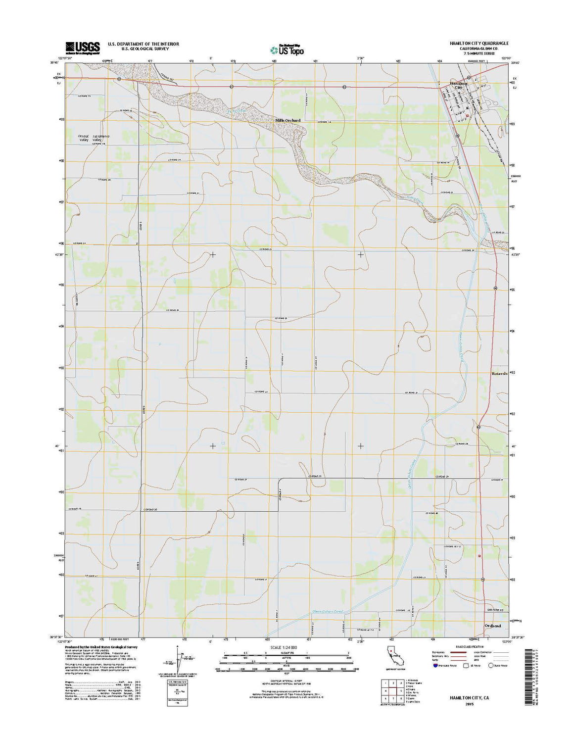

Hamilton City, CA
$ 8.95 $ 15.00
USGS Topo 7.5-minute map for Hamilton City 1. Kirkwood 2. Foster Island 3. 4. Orland 5. Ord Ferry 6. Willows 7. Glenn 8.


Orland, CA
$ 8.95 $ 15.00
USGS Topo 7.5-minute map for Orland 1. Black Butte Dam 2. Kirkwood 3. Foster Island 4. Fruto NE 5. Hamilton City 6. Stone Valley 7. Willows 8. Glenn


Foster Island, CA
$ 8.95 $ 15.00
USGS Topo 7.5-minute map for Foster Island 1. Corning 2. Vina 3. Richardson Springs NW 4. Kirkwood 5. 6. Orland 7. Hamilton City 8. Ord Ferry


Kirkwood, CA
$ 8.95 $ 15.00
USGS Topo 7.5-minute map for Kirkwood 1. Henleyville 2. Corning 3. Vina 4. Black Butte Dam 5. Foster Island 6. Fruto NE 7. Orland 8. Hamilton City


Black Butte Dam, CA
$ 8.95 $ 15.00
USGS Topo 7.5-minute map for Black Butte Dam 1. Flournoy 2. Henleyville 3. Corning 4. Sehorn Creek 5. Kirkwood 6. Julian Rocks 7. Fruto NE 8. Orland


Vina, CA
$ 8.95 $ 15.00
USGS Topo 7.5-minute map for Vina 1. Gerber 2. Los Molinos 3. Acorn Hollow 4. Corning 5. Richardson Springs NW 6. Kirkwood 7. Foster Island 8.
© 2025 FrugalNavigator.com. POS and Ecommerce by Shopify